Sunday, April 28, 2013

BASIC NAVIGATION: UNDERSTANDING TIME

Introduction


Having understood direction, distance and speed, it is now important to spend some time in getting to know time, as it impacts aviation. In the previous chapter we had referred to the formula that we learnt in school i.e. S = ut. In basic navigation we have no access to distance in the air and thus we have to rely on flying at a certain speed in a certain direction for a certain time to reach from A to B. Things would have been simple if the time at all places on the surface of the earth was same, but it is not so. Can you guess why?

Our body clock takes its cues from the rising and setting of the sun and thus we have evolved systems that help us with keeping track of time with respect to the sun. Since the earth is going around the sun and also revolving around its own axis, we need to understand the solar system before we can comprehend why we need different systems like UTC, IST, GMT, LMT, Zone time, etc.

  • Why is aviation stuck with UTC? Is there a better way?

Time and Our Solar System

The ETD of our flight is 0700Z and the flight duration is 8:00 hours. As we can see in this statement, we have used time in two distinct ways – as a particular instant of time and also as a duration of time. Duration of time poses no problem because we have gadgets like watches, clocks that can give us the duration very accurately. However, the basic datum against which we set the clock or watch is what is of greater concern to us since we have many different standards of time, or datum. 

However, taking due cognizance of our body bio-rhythmic clock, the basis of our time-keeping or datum has to be the Sun. We had studied the solar system in an earlier chapter. It must be understood that our solar system comprises the sun and nine major planets, including our earth, revolving around it in elliptical orbits. Each planet is at a different distance from the sun; with Mercury being the closest taking 88 days to complete one orbit; and Pluto being the farthest taking 249 years to complete one orbit around the sun. The motion of all these planets around the sun follows the Kepler’s laws of Planetary Motion, which are as follows: -

·         Each planet follows an elliptical orbit around the sun, with the sun being at one of the foci of the ellipse. When viewed from the North celestial Pole, the planets orbit in an anti-clockwise direction.
·         The line joining the planet to the Sun sweeps out equal areas in equal time, or,
o   Distance from sun increases – Speed of orbit reduces
o   Distance from sun reduces – Speed of orbit increases.

(All Images in this post are courtesy of Google Images. Please let me know of any copyright, and I would most willingly remove the images.)

Earth’s Motion

  • Rotates West to East about its axis of rotation
  • Makes one orbit around the sun in about 365 days, 5 hours, 48’ and 45”.
  • Axis of rotation of the earth tilted at an angle of 66.5° to the orbital plane or putting it another way at an angle of 23.5° from the normal to the orbital plane.

Seasons on the Earth

Seasons on the earth are caused primarily due to the tilt of the earth’s axis. This causes the sun to be directly over 23.5° N in midsummer in the Northern hemisphere and over 23.5° S in mid winter over the Northern hemisphere. When it is summer in the Northern hemisphere, it is winter in the Southern hemisphere and vice versa.

  • Why is it winter in the Southern hemisphere when it summer over the Northern hemisphere?

We would now talk only in terms of the Northern hemisphere. The following takes place:


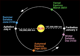
  • Summer: Earth is farthest from the sun (Aphelion) around 03 July with the Northern hemisphere tilted directly towards the sun; the sun being over its Northern most point on the earth, i.e. over the Tropic of Cancer (around 21 June), also known as the summer solstice for the Northern hemisphere
  • Winter: Earth is nearest to the sun (Perihelion) around 03 January with the Southern hemisphere tilted directly towards the sun; the sun being over its Southernmost point on the earth, i.e. over the Tropic of Capricorn (around 22 December), also known as the winter solstice for the Northern hemisphere.
  • Equinox: In between the two solstices are the spring (around 21 March) and the autumn (around 23 September) equinox (equal night), when the sun is directly over the equator leading to equal day and night on all parts of the earth.

Understanding Time and Different Types of Day that Man has devised

Sun’s Apparent Motion: As we have already discussed, the earth rotates around its own axis from West to East, or in an anti-clockwise direction when viewed from above the North Pole. If we consider the earth to be stationary, then it would appear that the sun travels around the earth in an East to West or clockwise direction. This is the reason why we say that the sun rises in the East and sets in the West. Also, while so traveling, the sun would cross all meridians of the earth.

Transit: The crossing of a meridian by a heavenly body is termed as a transit.
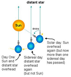
Sidereal Day: Two successive transits of a star is called a sidereal (star) day. One point that needs to be understood here is that stars are many light years away from the earth; whereas the earth is only 8 light minutes away from the sun. The long distance (infinite for all practical purposes) between the stars and the earth ensure that there would be negligible effect of the earth’s elliptical orbit around the sun on the time between two transits. This time is very nearly constant and is the time taken for the earth to complete one full 360° rotation around its own axis. This time is approx. 23h and 56’, and is called a sidereal day.


Apparent and Mean Solar Day: The motion around the sun is a little more involved. When viewed from the earth, the sun’s apparent clockwise motion around the earth would take approx 24 h for two successive transits if the earth were not revolving around the sun (same as a sidereal day). However, because the earth is revolving around the sun in approx 365 days (or it is traversing 1°/ day approx), it can be said that the successive transit would take place only after the earth has rotated through 361°. In addition, the motion of the earth around the sun follows Kepler’s law and is thus not at a constant speed because the earth’s distance from the sun is varying. Thus the apparent (True sun) solar day would also vary, and would not be a constant. This would be very inconvenient for timekeeping purposes. To overcome this problem, a mean solar day of 24 hours (the average value of the apparent solar days throughout the year) has been devised.

The Mean Sun: The mean sun is an imaginary body that moves approx with the apparent (real) sun – sometimes ahead and sometimes behind it. This mean sun ensures that our days are always 24 h, and very close to the real days. The discrepancy between the real (true or apparent sun) and mean sun (devised sun) is about 16’ later in November and about 14’ early in February. This discrepancy between the real and the mean sun is called the equation of time.

Leap Year

The earth takes 365d 5h 48’ and 45” to complete one orbit around the sun, and this is the astronomical year. Our seasons are as per this astronomical year. However, our calendar has only 365 d in a year, so if we do not add a day every fourth year, we would lose approx 6 h off our calendar every year. This would lead to seasons occurring in different months, over time. To ensure that the calendar year is synchronized with the seasons or astronomical year, an extra day is added to the month of February in every fourth year (a year that is divisible by 4 or leap year). The only exception to this rule is the century, when only every fourth century is a leap year (1600, 2000, and 2400). This is because in the leap years, we are catering for 6h instead of the actual 5h 48’ and 45”, and this time discrepancy has to be adjusted once in every 400 years. All this is done to keep the stability of seasons so that they occur on around the same dates every year.

Mean Solar Time and Arc

The mean sun takes 24 h to go around the earth, or 360° of arc. Its motion in degrees of longitude and time can thus be worked out as follows: -

  • Time                                                      Arc of Longitude
  • 24 h                        =                             360°
  • 1h                           =                             15° (360°/ 24h)
  • 4’                           =                             1°  
  • 1’                            =                             15”

Local Mean Time (LMT)

Local mean time is the time kept using the observer’s local anti-meridian and the mean sun in the following manner: -

  • Day starts (0000 h) when mean sun at anti-meridian, and ends after 24 h (2400 h) with sun on the same anti-meridian.
  • As the mean sun goes around the earth in a clockwise direction, any place East of the observer’s meridian would be ahead of the observer’s LMT, and any place West of this would have a LMT behind the observer’s LMT. The LMT can be calculated by using the arcs of longitude, as given above.

Universal Coordinated Time (UTC)

LMT at each meridian would be different. This would pose certain problems. Thus there was a need to have a time that was same all across the world. This time was the GMT or Greenwich Mean Time, or the LMT at Greenwich. The modern name for GMT that is approved by ICAO is UTC. It is the same as the GMT for all practical purposes, and is also the standard time used for all aviation related activities. However, this cannot be used for normal living by all people around the earth due to our body bio-rhythms.

Zone Times

In this system, each zone comprises of 15° of longitude (1 hour) and has a zone time. There are a total of 25 zones, starting with ‘Z’ (from 7.5°W to 7.5°E) and every 15° thereafter. Time zones around the International Date Line are only 7.5°. The time zones comprise the letters of the alphabet except ‘J’. The numbers in blue are to be added to the UTC to get the zone time; and the numbers in purple are to be substracted from teh UTC to get the zone time.

Standard Time

Zone time runs in to problems when countries stretch across more than one time zone. There is thus a need felt to have a standard time for the entire country or for designated parts of the country. This is the standard time for that country. IST is the LMT at Allahabad (82.5°E). This is used as a standard time for the whole of India. Longitude 82.5°E falls on the line between E and F time zones and thus IST is also referred to as EF. Countries like USA and Canada have more than 1 standard time. Standard times cannot be calculated unlike zone times. One needs to refer to tables to find the standard time.

Summer – Daylight Saving Time

As one goes away from the equator, the days are much longer in summer. To conserve energy, some countries that are in the higher latitudes have introduced something known as Daylight Saving Time during summer (which is six months apart in the Northern and the Southern hemisphere). Actual dates are published in the time charts. It is easy to remember the changes to the clock by the following rhyme: -

  • Spring forward in spring
  • Fall back in fall.

International Date Line (IDL)

The anti-meridian to the Prime Meridian is the general reference for the International Date Line. It does not follow the meridian exactly, but is curved at a few places to accommodate populated areas to one side of the date line.

The significance of the IDL is that the date changes when one crosses the IDL towards Easterly or Westerly direction, in the following manner: -

  • Traveling on an Easterly heading – subtract one day from the date or lose a day.
  • Traveling on a Westerly direction – add one day to the date or gain a day.

Time however continues to be the same. To prevent problems when crossing the IDL during a flight or in calculations, it is advisable to work in UTC before changing over to ST or LMT.

Thumb Rules

  • Longitude East, UTC least
  • Longitude West, UTC best.
  • Easterly direction travel across IDL – Lose a day
  • Westerly direction travel across IDL – Add a day.
  • Arc times: -
    • 24h                         -                              360°
    • 1h                           -                              15°

Saturday, April 27, 2013

AIRASIA INDIA'S GAME PLAN


AirAsia India has filed for a No Objection Certificate (NOC) with the Aviation Ministry on 23 Apr 2013, after having obtained formal approval of the Foreign Investment Promotion Board (FIPB) on 06 Mar 2013. The NOC is for the launch of a low cost airline in India as a joint venture between AirAsia, Tata Sons and Telestra Tradeplace in the ratio of 49: 30: 21.   This newly-formed airline is the Indian arm of Malaysia's low-cost carrier group AirAsia, which is going to exercise control over its operations. As per reports, AirAsia India has plans to launch operations starting with 3 - 5 aircraft based in Chennai, and plans to connect small towns and cities in the South. Thereafter, as per reports, it proposes to ramp up to 36 planes in five years, with 12 each based at Chennai, Bangalore, and Kolkata. Dr Tony Fernandes, the AirAsia Group CEO is quoted to have said that, “India will be the final piece of the puzzle for the time being and there will be no further joint ventures”. He believes that India is a “huge opportunity” and that he has not “jumped in quickly”. He believes that AirAsia has done their homework and are entering “into the domestic market with eyes wide open”. Fernandes believes that a number of failures in the Indian market had been due to cost levels, and thus argues that cost would be the main differentiator in the Indian venture. How does he plan to keep the cost low?

India is known for high operating costs in terms of taxes, airport charges, landing and navigation charges, etc. This has been one of the contributing factors, besides others, for the losses that have continuously been mounting at the airlines. A study of the annual financial results of the three listed airlines, Jet Airways, Kingfisher Airlines and Spice Jet, from March 2008 to March 2012 indicates that they have been making huge overall losses every financial year; Spice Jet  made relatively small profits in FY 2009-10 and 2010-11. Reportedly Indigo Airlines, an unlisted airline, is the only one that has made consistent profits; although even it made a loss of Rs 80 Crores in FY 2011-12. Mounting losses led Kingfisher to gradually cut down on its services, and eventually it ceased to operate in the latter half of 2012. The closure of Kingfisher operations was good news for the remaining airlines, which made a profit in the QE Dec 2012, by commanding better ticket prices due to the sudden demand/ supply mismatch. India is known to have a very challenging environment for airlines to launch and sustain operations; we have had many start-ups like East West, Modiluft, Damania, and now Kingfisher fail. It is under these circumstances that AirAsia India is confident of replicating its proven business model in India; a ‘low cost, no frills’ model that assures low fares to the passengers, along with profits for the company. Considering these facts, will AirAsia be able to expand the available passenger base so that the profitable demand/ supply equation is not affected, after the increase in the number of players and services? What is it that AirAsia India would do differently from what the other three purely low cost carriers (LCC) operating in India has not been able to do thus far?

Fernandes conceded that, “It has been tough for us to develop a low-cost structure to compete effectively in India”,  and goes on to add that “we now have the recipe to achieve this”. Tony Fernandes told CNBC that he was confident the airline's "really low cost product" would work in India. All this sounds cliché and the real test is going to be in how this attractive new product is going to be configured. The company’s vision statement may hold some answers. AirAsia’s vision is “To be the largest low cost airline in Asia and serving the 3 billion people who are currently underserved with poor connectivity and high fares”. Flowing from this, one of the mission statements is “To attain the lowest cost so that everyone can fly with AirAsia”. To achieve this, the key strategies are “Safety First, High Aircraft Utilisation, Low Fare, No Frills, Streamline Operations, Lean Distribution System, and Point to Point Network”. This is not something visionary that the other low cost carriers already operating in India are not privy to. What specifically is AirAsia India going to do that the others have not been able to do?

The most important difference between the present Indian LCCs and AirAsia India is that AirAsia India is part of a larger group that has deep pockets. Also, the group already has a large international network in place to 19 countries, along with domestic operations in 5 of these destination countries. Relevant to AirAsia India operations, the group is already operating international services to 5 destinations in India, and is connecting these cities to 23 destinations in 17 countries in the East, including Malaysia, Thailand, China and Australia. A study of the group network reveals that it is operating to 99 destinations in 19 countries, as on 17 Apr 1013. Comparing this with the present Indian LCCs is informative. The three LCCs in India primarily operate domestically within India, with limited international operations; Indigo operates to five international destinations in five countries; Spice Jet is operating to 8 international destinations in eight countries; GoAir is yet to commence international operations because of the government policy of 20 aircraft/ 5 years.

Also, AirAsia group has a total of 120 A-320s aircraft as on date. Compare this with Indigo’s 62; Spice Jet’s 48; and Go Air’s 13 as on 07 Dec 2013, as per the DGCA website. AirAsia group has a further order of 360 more A-320s/ A-320 Neo aircraft that are due to be delivered by 2026; this is excluding the leased aircraft. AirAsia group strength by the end of 2013 is likely to reach 150. All these factors give AirAsia India an advantage over the present Indian LCCs. More importantly, these factors help AirAsia India to technically circumvent the Indian government restriction of ‘20 aircraft/ requirement of 5 years domestic experience’ before a carrier can fly to international destinations that most of the present carriers have had to put up with. The already challenging Indian aviation environment is even more challenging with these restrictions.

India is a large country with a very well developed railway network that links to every small town across the country. As against this, the country has only 67 licenced aerodromes for public use, as per the DGCA website; adding a few defence and other airports to this still does not match the reach of the railways. It can thus be said that infrastructural constraints restrict a large population of India to access air travel, whereas rail travel is conveniently available to a majority of the population. Also, Indians by nature are very value conscious, and time is not yet considered a valuable resource with the vast majority of us. In addition, railways are considered a common man’s mode of travel and are also the largest public sector employer. These facts lead the government to directly and indirectly subsidise the operations, reflected in cheap rail tickets. Air travel is still considered elitist and thus is heavily taxed, which fact is again reflected in the ticket pricing. The large difference in ticket pricing between the railways and the airlines is one of the factors that is hampering rail passengers from making the switch to air travel. Air travel would grow much faster if the air tickets could be priced somewhere between the cost of 2nd AC and 1st AC train tickets. This can realistically happen only if the dynamics of the free market govern the ticket pricing of the railways, like in the case of the airlines. Air Deccan had unrealistically attempted this approach, but had bled through the process; it was however successful in luring rail passengers to travel by air.

Air travel is the preferred mode of travel when either natural or manmade barriers add problems to travelling by surface. Going across hills/ mountains/ large water bodies, or across international borders are good examples where air travel automatically becomes the preferred mode of travel. It is a fact that holiday packages in the tourist friendly ASEAN countries are very slightly more expensive than domestic holidays. It is also common knowledge that many utility items are available at much lower prices in these countries. These two facts open up a host of possibilities for AirAsia India. The low cost of items bought abroad helps partially offset the higher cost of the holiday, and also, people are happier to go abroad for their holidays. Indian government policies, limited & poor infrastructure at domestic tourist destinations and the Indian people’s fascination for travel abroad will work to the advantage of this new airline, as AirAsia’s focus customer is the leisure traveller. AirAsia India’s entry in to the Indian airspace will lead to a large increase in connectivity between India and the rest of Asia in the East. AirAsia India will be able to convert a lot of domestic leisure travellers to travel abroad Eastwards, by serving as a seamless feeder airline for the already established airlines of the group. In doing this it would be giving tough competition to the other Indian LCCs domestically. As per reports in the press, the airline in keeping with its strategy of keeping costs as low as possible, is likely to discontinue some status quo items of the Indian aviation sector; items like free transportation and free meals for the flight crew. This may discourage some experienced flight crew from joining the airline. However, this is not likely to pose a problem presently, as Kingfisher Airlines crew who happen to be qualified and experienced on A-320s are presently available to meet the initial requirements of this airline.

Innovative schemes are another hallmark of this group. Even before it had applied for the NOC, the group had announced up to 70 percent discount on international flights from India. The group offered two million seats under this scheme for bookings done in April this year for travel period between 01 January and 30 April 2014. The group is also known to earn 18% of its total revenue from ancillary sales. These and other such innovative features are likely to help AirAsia India maintain its profitable edge even in a challenging aviation market like India. How the other LCCs are going to fare is something that we will have to wait and watch.  

Friday, April 26, 2013

BASIC NAVIGATION: TRIANGLE OF VELOCITIES


Having understood direction and distance, it is now important to understand speed and velocity, as relevant to air navigation. This is primarily because in basic air navigation there is no way of measuring distance in the air. Distance can only be estimated by the formula that we learnt in school, viz. S = ut, or distance is equal to velocity multiplied by time flown. It would be simple if the medium through which we fly remained stationary.

However, the medium of air through which we fly is moving too, displacing our aircraft along with it. You will study the ‘what’ and ‘why’of winds in your meteorology classes. You must have flown kites, and should thus be pretty familiar with how they drift with the wind. Aircraft, even the largest ones, are affected in a similar manner by these same winds. In this chapter we will try and understand the constituent parts of the velocity triangle that forms the basis of air navigation.

Speed and Velocity: Speed is a linear quantity, whereas velocity is a vector quantity. Speed is distance covered in a unit of time, whereas velocity is speed in a given direction. Both are expressed in knots or nautical miles/ hour. In air navigation we are concerned with the following velocities: -

  • Aircraft velocity through the air – given by True Air Speed (TAS) and heading (direction in which the fore and aft axis of the aircraft is pointing) (Single arrow)
  • Aircraft velocity on the ground – given by Ground speed and Track (Twin arrow)
  • Wind velocity – Speed and direction of the wind. (Three arrows)


Vectorial Addition: Since all of the above are vector quantities, they can all be represented graphically by straight lines in the given direction. The length of the lines would be proportionate to the speed at a given scale. We can vectorially add two vectors and get the resultant third vector. An aircraft going from place A to B is subjected to its own velocity (TAS and heading) through the air, and the wind velocity. (Wind velocity is the speed of the wind and direction from which it is blowing). Both these vectors combine to produce a resultant, the third vector comprising of the speed and the direction that the aircraft follows on the ground, known in aviation as ground speed and track.

The Velocity Triangle: The velocity triangle comprises of six variables, as shown above – TAS, G/S, Heading, track, wind direction and wind speed. In case we know any four it would be possible to find out the other two by solving the velocity triangle. In air navigation, we can measure the desired track to go from A to B from the map or chart; we can find the best TAS to fly for the desired altitude from the POH; and the wind velocity can be obtained from the meteorological briefing. With these four variables known, it is possible to find the other two, viz. the heading and the ground speed, by solving the velocity triangle with the help of the Dalton computer or electronic flight computer.

Drift: Drift is a direct consequence of the wind velocity – if the wind is from the left, the aircraft would drift to the right (starboard drift), and vice versa. In a pilot’s language, with a wind from the left, the pilot would need to offset the aircraft nose into the wind or to the left in order to maintain the desired track on ground, or heading would be left of track for a starboard drift. 
  • It is important to understand drift and the consequent offset of the aircraft nose required to counter it. 
  • Drift is the angular difference between the heading and track of an aircraft, and is port or starboard depending on whether the track is port or starboard of heading.
Solve: In nil wind conditions what is the relationship between TAS and GS.
Solve: In nil wind conditions what is the drift.
Solve: An aircraft is preparing to land on an airfield with two runways; 09/ 27 and 12/ 30. The reported surface winds are 120/ 30 kts. After landing the pilot applies the same braking pressure in all cases.
  • Which is the best runway to land on? Why?
  • On which approach would the aircraft appear moving the slowest to a ground observor? Why?
  • On which approach would the aircraft have the highest rate of descent? Why?
  • On which runway would the aircraft stop in the shortest distance? Why?
  • In case the aircraft were to plan landing on all four runways - list out the brake temperatures at the end of the landing roll in each case, from hottest (4) to coolest (1).

Wednesday, April 24, 2013

BASIC NAVIGATION: DISTANCE AND DEPARTURE


Introduction: To go from one place to another through the medium of air, we need to know the direction and the distance between the places. Having studied direction in the previous chapter, let us now focus on the distance. Distance is once again measured on the map or chart and annotated on the flight plan in the relevant column.

Units of Measurement

In air navigation we have various units of measuring distance. We need to understand each of these units. Larger units that we come across in aviation are the nautical mile (nm), the kilometer (km) and the statute mile (sm).  We should be able to convert from one unit of the above units to another and also in to the smaller units of meter, centimeter, millimeter, yards, feet, inches, etc.

Nautical mile: A nm is defined as the arc of a meridian subtending an angle of 1’ at the centre of curvature of that section of the meridian. Since earth is an oblate spheroid, the length of the arc varies from 1843 meters at the equator to 1862 meters at the poles. It is nearly correct (1853m) at 45° latitude, when compared to the ICAO standard of 1852m. One nm is taken to be equal to 6080 feet in calculations.

·         For all practical purposes while calculating distances, it is assumed that one nm is equal to the length of an arc of a great circle subtending an angle of 1’ at the centre of the earth.

Kilometer: One kilometer is the length of 1/ 10,000th part of the average distance between the equator and the poles. It is equal to 3280 feet. 

Statute Mile: It is decreed by British law that one statute mile is equal to 5280’.

  • What is the circumference of the earth in nm, and in km?
    • Hint: 1’ = 1 nm; 1° = 60 nm; 90° = ?; 360° = ?
  • What is the radius of the earth?
    • Hint: Circumference = 2Ï€r; r = ?
  • What is the average speed at which the earth is going round its own axis (due to rotation) at the surface of the earth at the equator?
    • Hint: Earth completes on revolution around its own axis in 24 hours.

Conversions

  • 41 nm = 76 km; 66 nm = 76 sm
  • 1 nm = 1.15 sm = 1.85 km = 6080’
  • 1 km = 1000 m; 1 m = 100 cm; 1 cm = 10 mm.
  • 1 m = 3.28’; 1’ = 12”.
  • 1 yard = 3’
  • 1’ = 30.5 cm; 1” = 2.54 cm.

Calculating Great Circle or Shortest distances between two points

  • Both places on same meridian – Same and opposite hemisphere cases.
·         Hint: Meridians are semi great circles
·         Solve: Distance between 30N 7853E and 3753N 7853E is …………
·         Solve: Distance between 3506N 2945W and 3552S 2945W is ……….
  • Both places on the equator -  same and opposite hemisphere case
    • Hint: Equator is a great circle
    • Solve: Distance between 00N 2936E and 00N 1242W is …………..
    • Solve: Distance between 00N 2953E and 00N 17836E is ………..
  • Both places on meridian/ anti-meridian – Same and opp. Hemispheres.
    • Hint: Again a great circle case
    • Solve: Distance between 20N 160E and 30N 020W is …………
    • Solve: Distance between 20S 140E and 60N 40W is ……….

Departure

Departure is the distance in nm between two places located on the same parallel of latitude. Since these two places will always be 090°/ 270° of each other, as all parallels of latitude cut the meridians at 90°; this is also the rhumb line distance between the two places.

A look at the globe should convince us that if two places on the same parallel of latitude were on the same two different meridians, say 30° E and 40° E, at the equator or at the pole then the distance between them would be different, although being on the same meridians the ch long in both these cases would remain the same; the distance between them would be maximum at the equator and zero at the poles. Thus it can be seen that departure is a cosine function and would vary as the Cosine of the latitude. At the equator, latitude is 0° and cosine 0 = 1 and at the poles, the latitude is 90°, and cosine 90 = 0, 

Or

  • Departure (nm) = Ch long (minutes) X Cos Lat.
  • 1’ = 1 nm at the equator
  • Solve: Find the shortest and the rhumb line distance between 45N 120E and 45N and 60W
  • Solve: Find the constant true direction and great circle distance between 30S 90E and 30S 90W

Tuesday, April 23, 2013

BASIC NAVIGATION: DIRECTION


We are used to travelling on the surface of the earth. To go from one place to another, we follow a highway that is built between the two locations. In the air, we do not have any highways and thus for basic navigation, we need to follow directions to go from place A to B.

Background: Traditionally, the direction from which the sun rises is called the East; the direction in which it sets is called West. When facing East, the direction on your left is called North, and direction to the right is called South. These four directions are called the cardinal directions. Directions in between the four cardinal directions, i.e. NE, SE, SW and SE, are called the quadrantal directions.

Definition of Direction: Direction is the angle measured clockwise from datum North. The direction is called True if the datum is the True North or the Geographical North; it is Magnetic if the datum is the magnetic North; and is Compass if the datum is the compass North. Direction is always expressed in a three figure group, with suffix of (T), (M), and (C) defining the datum, True, Magnetic or Compass respectively. An angle measured 1 degree from the datum Magnetic North would thus be annotated as 001* (M).

True North: True North is the direction of the North pole, and is indicated on maps by the meridians. Thus to measure True directions on a map the protractor should be aligned with the true meridian. Guess what is the direction of the geographic North pole?

Magnetic North: Magnetic North is the direction in which a freely suspended magnetic needle, which is only subject to the earth’s magnetic field, would point. The direction of this freely suspended magnetic needle is also known as the magnetic meridian and is the datum for measuring magnetic directions.

Compass North: A freely suspended magnetic needle when positioned in an aircraft is influenced by the electro-magnetic fields in the aircraft, in addition to the earth's magnetic field, and would thus point in a direction that is different from the magnetic North. This direction towards which it would point in a given aircraft is called the Compass North.

Practical Aspects: In navigation, we need to travel from one place to another on the surface of the earth. The direction to be flown between two places on the surface of the earth is measured from the map or chart. This direction is the true direction. However, in basic navigation we do not have the means to fly the true direction and thus need to use a magnetic compass. Since magnetic and compass direction may not be the same as true direction, we can only use the magnetic compass to steer the true direction if we know the angular difference between the magnetic North and true North (variation) and also the difference in the compass North and magnetic North (deviation).

Variation: The angular difference between the true and magnetic North at any given place is called Variation. It is measured in degrees East or West, depending on whether the magnetic North is to the East or West of the True North. Variation at any given place on the map/ chart can be found by looking for the lines joining places of equal variation – isogonic lines or isogonals. Lines joining places of zero variation are known as agonic lines.

Deviation: The angular difference between the magnetic and compass North on any given aircraft is called deviation. Deviation is measured in degrees E or W of the magnetic North depending on whether the compass North is E or W of the magnetic North. Since deviation is dependent on the electro-magnetic fields of the aircraft, it is logical that deviation would be different on different aircraft, and also on different headings of the aircraft. Deviation for any particular aircraft can be found on a deviation card installed next to the magnetic compass on the aircraft.

Finding Magnetic direction from True direction: Variation E is designated (+) and W is (-). To find true direction from magnetic direction, one needs to algebraically add the variation to the magnetic direction. It is much easier to remember the thumb rule

·         Variation East Magnetic least
·         Variation West Magnetic best.

Finding Magnetic direction from Compass direction: Deviation E (+) and W (-) are algebraically added to the compass direction to get magnetic direction. It is once again easier to remember the thumb rule

  • Deviation East Compass least
  • Deviation West Compass best.
 Compass Error: Compass error is the algebraic sum of the variation and deviation.

Practically while preparing the flight plan on the ground, we start with measuring the true direction on the map or chart; look for the variation at that place on the same map or chart and apply that to get the magnetic direction to be flown. All this is calculated and put down in the flight plan form before we proceed to the aircraft. Once we reach the aircraft, we check the deviation card and apply the relevant deviation to the magnetic direction calculated as per the flight plan and we can now fly the true directions on the magnetic compass in that aircraft.

BASIC NAVIGATION: THE BASIC BUILDING BLOCKS


Air Navigation: The art of going from place A to B, through the medium of air, safely.

Solar System and the Earth: Our solar system comprises of nine planets revolving around the sun at different distances. The closest planet to the sun is ‘Mercury’, followed by Venus, Earth, Mars, Jupiter, Saturn, Uranus, Neptune; with Pluto being the farthest from the Sun. Mercury completes one orbit around the Sun in about 88 days and Pluto in about 249 years.

Sphere: A sphere is a solid body bounded by a surface upon which all points are equidistant from the centre. Radius of all points on the surface of the sphere is the same.

The Earth 

The Earth revolves around the Sun in an elliptical orbit, taking about 365¼ days to complete one orbit. It also rotates around its own axis, from West to East, once in approx 24 hours. Its axis of rotation is tilted at an angle of 66.5° to the elliptical plane of its revolution around the sun. This causes seasons. Its rotation about its own axis causes day and night.

The earth is an oblate spheroid – i.e. not a perfect sphere, but can be considered to be a perfect sphere for all practical purposes. It is flattened at the poles, with the equatorial diameter (12748.6 kms) being 43 kms more than the polar diameter (12705.6 kms). The flattening at the poles is called Compression.

Compression Ratio = 43/12748.6 = 1/ 296.5 

Poles 

The points of intersection of the axis of rotation of the earth and the earth’s surface are called poles – North and South pole. The names have been arbitrarily selected. The North pole is the pole about which the earth rotates anti-clockwise; and rotates clockwise about the S-pole, when viewed from above the respective pole. 

Great Circle (GC)

It is a circle on the surface of the sphere (earth) whose radius and centre are same as that of the earth. It is the largest circle that can be drawn on the surface, and thus its name. A GC has certain properties. These are as follows: -

• It divides the sphere into two equal halves.
• It has the same radius and centre as the sphere.
• Only one GC can be drawn through two points not diametrically opposite.
• Any number of GCs can be drawn through two diametrically opposite (anti-podal) points.
• The shortest distance between two places is the smaller arc of the GC drawn through them.

Small Circle

Any circle on the surface of the sphere (earth) that is not a GC is a small circle. A small circle’s radius and centre would thus not be the same as that of the earth.

Equator

Equator is a GC whose plane is at right angles to the axis of rotation of the earth, and it divides the earth into two equal halves – the Northern and Southern hemispheres. It is the datum for measuring latitude. Thus latitude is either North or South of the equator. Also, equator itself is 0
° latitude.

Meridians

Meridians are semi GCs joining from pole to pole. Thus every GC passing through the poles comprises of a meridian and its anti-meridian. All meridians cut the equator at 90°.

Rhumb Line (RL)

A RL is a regularly curved line on the surface of the earth that cuts all meridians at the same angle. It can also be called as the line of constant true direction. So, aircraft flying constant true track would be flying RL track. Other points of interest are: -

• Only one RL can be drawn through any 2 points.
• RL is not the shortest distance between 2 points, but is convenient to fly. 
• All meridians and equator are the only examples of GC that are also RL.
• All parallels of latitude and meridians intersect with each other at 90°. So all parallels of latitude are RLs.

Prime Meridian (PM)

The meridian passing through Greenwich Village (close to London) is called the Prime Meridian, and is the datum for measuring longitude. Thus longitude is either East or West of the Prime meridian. Also, the longitude of the PM is 0
°.

Parallel of Latitude

Parallels of latitude are small circles whose plane are parallel to the plane of the equator, and cut all meridians at 90°.

Graticule

This network of parallels of latitude and the meridians drawn on the surface of the earth is called a graticule.

Latitude

Latitude of a place is the arc of the meridian between the equator and the parallel of latitude on which the place lies. It is measured in degrees, minutes, seconds North or South of the equator. (1
° = 60’ and 1’ = 60”). Latitude is the angular distance along the meridian.

What is the latitude of the North pole? Why? Can you explain.

Longitude

Longitude of a place is the smaller arc of the equator measured between the PM and the meridian passing through the place. It is measured in degrees, minutes and seconds East or West of the PM. Longitude is the angular distance along the equator.

Defining Position on the Earth 

Position on the earth can be defined in any of the following manners: -

• Place Name
• Bearing and distance from known place
• Latitude/ Longitude 

Conventionally a place is defined in lat/ long, by the latitude first followed by the longitude. As an example, place A is defined as 2354N 7305E. This implies that the place is 23* 54’ North of the equator and 73* 05’ East of the PM.

Change of Latitude or Difference of Latitude (Ch lat or D lat)

Ch lat between two places is the arc of the meridian intercepted between their respective parallels of latitude, and can be North or South depending upon the direction of change.

Discuss Ch lat in same hemisphere/ opposite hemisphere. 

Change of Longitude or Difference of Longitude (Ch long or D long)

Ch long between two places is the smaller arc of the equator intercepted between the meridians passing through the two places, and is East or West depending on the direction of change.

Discuss Ch long in same hemisphere/ opposite hemisphere.

Friday, April 19, 2013

AIR INDIA EXPRESS ACCIDENT AT MANGALORE: 22 MAY 2010

(Adapted from Flight Safety Foundation website)

The outbound flight IX-811 of Air India Express between Mangalore and Dubai was uneventful and landed at Dubai at 01:14 IST. The airplane was serviced and refuelled. The same flight crew operated the return leg from Dubai to Mangalore as flight IX-812. The airplane taxied out for departure at 02:36 IST. 

Take-off, climb and cruise were uneventful. During the flight, there was no conversation between the two pilots for about 1:40 hours because the Captain was asleep. The First Officer was making all the radio calls.
The aircraft reported position at IGAMA at 05:33 hours IST and was advised to expect an ILS DME Arc approach to Mangalore. At about 130 miles from Mangalore, the First Officer requested descent clearance, which was denied by the Mangalore Area Controller, who was using standard procedural control to ensure safe separation with other air traffic. The flight was advised to call at 80 DME. At 05:46 IST, the flight reported 80 DME, as instructed by Mangalore Area Control. The aircraft was cleared to 7000 ft. The aircraft commenced descent at 77 DME from Mangalore at 05:47 IST. The visibility reported was 6 km.

Mangalore airport has a table top runway, best described by AIP India as, "Aerodrome located on hilltop. Valleys 200ft to 250ft immediately beyond paved surface of Runway." Owing to the surrounding terrain, Air India Express had made a special qualification requirement that only the PIC shall carry out the take- off and landing. The Captain on the accident flight had made a total of 16 landings in the past at this airport and the First Officer had operated as a Co-pilot on 66 flights at this airport.

While the aircraft had commenced descent, there was no recorded conversation regarding the mandatory preparation for descent and landing briefing as stipulated in the SOP. After the aircraft was at about 50 miles and descending out of FL 295, the conversation between the two pilots indicated that an incomplete approach briefing had been carried out. At about 25 nm from DME and descending through FL 184, the Mangalore Area Controller cleared the aircraft to continue descent to 2900 ft. At this stage, the First Officer requested, if they could proceed directly to Radial 338 and join the 10 DME Arc. Throughout the descent profile and DME Arc Approach for ILS 24, the aircraft was much higher than normally expected altitudes. The aircraft was handed over by the Mangalore Area Controller to ATC Tower at 05:52 IST. The Tower controller, thereafter, asked the aircraft to report established on 10 DME Arc for ILS Runway 24. By now the yawning by the First Officer recorded on the CVR indicated that even he was showing signs of tiredness. This flight was operating in WOCL (Window of Circadian Low). On having reported 10 DME Arc, the ATC Tower had asked the aircraft to report when established on ILS.

It appears that the Captain had realised that the aircraft altitude was higher than normal and had selected Landing Gear 'DOWN' at an altitude of approximately 8,500 ft with speed brakes still deployed in Flight Detent position, so as to increase the rate of descent. As indicated by the DFDR, the aircraft continued to be high and did not follow the standard procedure of intercepting the ILS Glide Path at the correct intercept altitude. This incorrect procedure led to the aircraft being at almost twice the altitude as compared to a Standard ILS Approach.

During approach, the CVR indicated that the Captain had selected Flaps 40 degrees and completed the Landing Check List. At 06:03 hours IST at about 2.5 DME, the Radio Altimeter had alerted an altitude of 2500 ft. This was immediately followed by the First Officer saying "It is too high" and "Runway straight down". In reply, the Captain had exclaimed "Oh my god". At this moment, the Captain had disconnected the Auto Pilot and simultaneously increased the rate of descent considerably to establish on the desired approach path. At this stage, the First Officer had queried "Go around?" To this query from the First Officer, the Captain had called out "Wrong loc .. ... localiser .. ... glide path".  

The First Officer had given a second call to the Captain for "Go around" followed by "Unstabilised". However, the First Officer did not appear to take any action, to initiate a Go Around. Having acquired the runway visually and to execute a landing, it appears that the Captain had increased the rate of descent to almost 4000 ft per minute. Due to this, there were numerous warnings from EGPWS for 'SINK RATE' and 'PULL UP'. On their own, the pilots did not report having established on ILS Approach.

Instead, the ATC Tower had queried the same. To this call, the Captain had forcefully prompted the First Officer to give a call of "Affirmative". The Tower controller gave landing clearance thereafter and also indicated "Winds calm". The aircraft was high on approach and touched down on the runway, much farther than normal.

The aircraft had crossed the threshold at about 200 ft / IAS in excess of 160 kt, against the target of 50 ft and 144 kts for this landing weight. Despite the EGPWS warnings and calls from the First Officer to go around, the Captain had persisted with the approach in unstabilised conditions. Short of touchdown, there was yet another (Third) call from the First Officer, "Go around captain...We don't have runway left". However, the Captain had continued with the landing and the final touchdown was about 5200 ft from the threshold of runway 24, leaving approximately 2800 ft of remaining paved surface.

The Captain had selected Thrust Reversers soon after touchdown. Within 6 seconds of applying brakes, the Captain had initiated a 'Go Around', in contravention of Boeing SOP. The aircraft overshot the runway including the strip of 60 metres. After overshooting the runway and strip, the aircraft continued into the Runway End Safety Area (RESA) of 90 metres. Soon after which the right wing impacted the localiser antenna structure located further at 85 metres from the end of RESA. Thereafter, the aircraft hit the boundary fence and fell into a gorge.

(Image Courtesy: ARKarthik.com

CAUSE OF THE ACCIDENT

Direct

The Court of Inquiry determines that the cause of this accident was Captain's failure to discontinue the 'unstabilised approach' and his persistence in continuing with the landing, despite three calls from the First Officer to 'go around' and a number of warnings from EGPWS.

Contributing Factors to the Accident

1.            In spite of availability of adequate rest period prior to the flight, the Captain was in prolonged sleep during flight, which could have led to sleep inertia. As a resu lt of relatively short period of time between his awakening and the approach, it possibly led to impaired judgment. This aspect might have got accentuated while flying in the Window of Circadian Low (WOCL).

2.            In the absence of Mangalore Area Control Radar (MSSR), due to unserviceability, the aircraft was given descent at a shorter distance on DME as compared to the normal. However, the flight crew did not plan the descent profile properly, resulting in remaining high on approach.

3.            Probably in view of ambiguity in various instructions empowering the 'copilot' to initiate a 'go around ', the First Officer gave repeated calls to this effect, but did not take over the controls to actually discontinue the ill-fated approach.